Yingying Wang
Sensory Resilience in Urban Walkingscapes: Space making strategies for streetside public systems in neuro- inclusive city visions
The thesis asks spatial designers of the public realm to pay attention to sensory profiles and related issues in contemporary urban contexts: sensory overstimulation, lack of safety, security, accessibility in public, absence of clarity, and legibility in the navigating system. These features have characterized rigid and homogeneous representations of and solutions for existing public spaces, mostly developed with a lack of knowledge of humans’ diverse sensory needs in different environments. They fail to offer users – especially neuro-minority groups – alternative ways to interact with the public sphere.
The study researches the reasons for such approaches while investigating the relationships between human sensory profiles and public landscape design. It also aims to position a personal design approach that offers a variety of design methodologies and an actionable public space renovating vision.
The project explores potential renovation strategies that design practice could offer, through site sensory mapping and spatial experiments. With a focus on alternative walkingscapes, it experiments with different pedestrian-based systems that cater for a broader range of sensory experiences.
The thesis aims to reveal how designers should accept their ability and responsibility to develop ideas towards building sensory resilient urban public space systems that could benefit wider groups of users with diverse identities and neuro-cognitive abilities.
Image
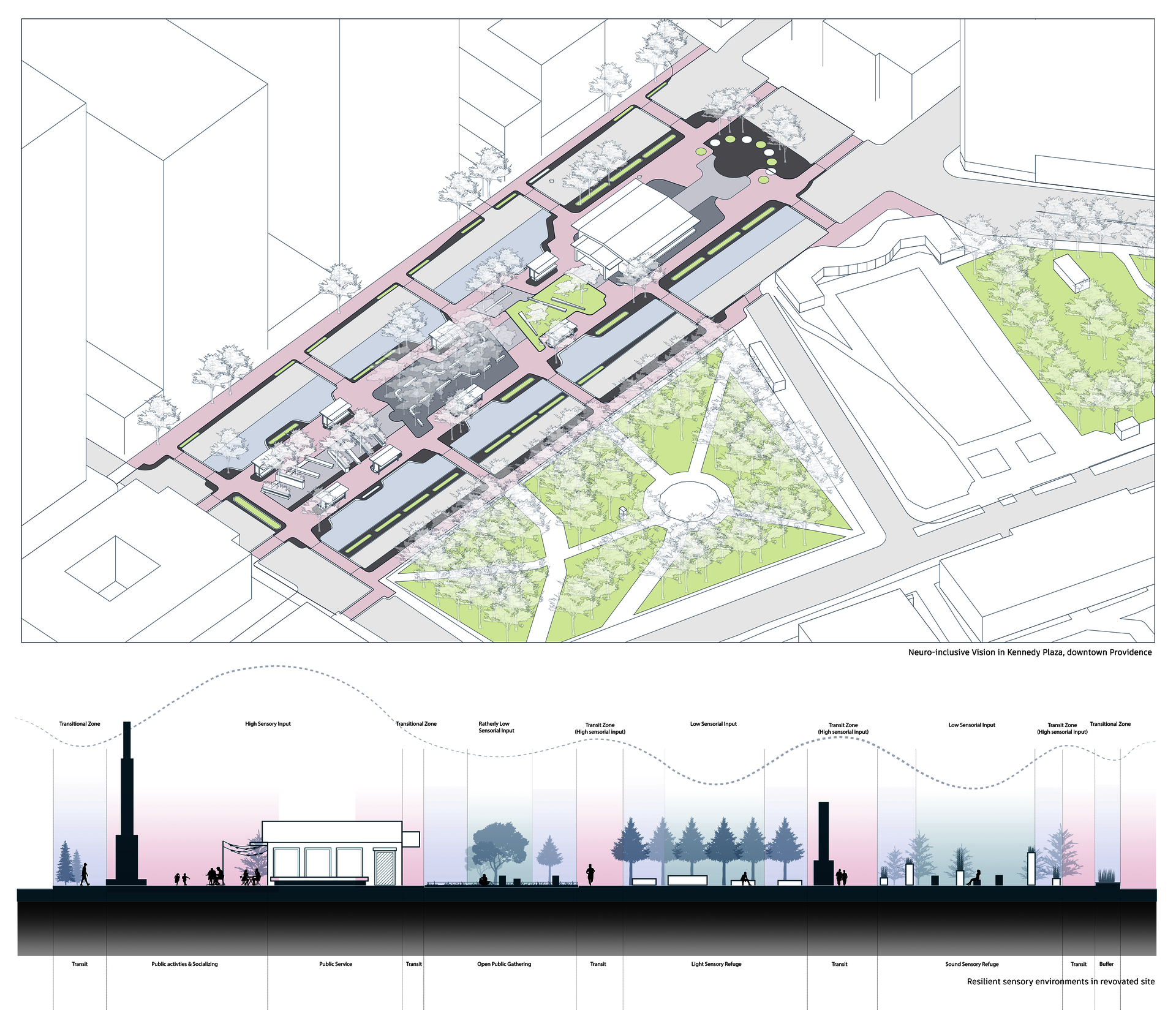
Neuro-inclusive Vision in Kennedy Plaza, Providence
CONTEXTULIZATION:Neurominorities and Urban sensory environments
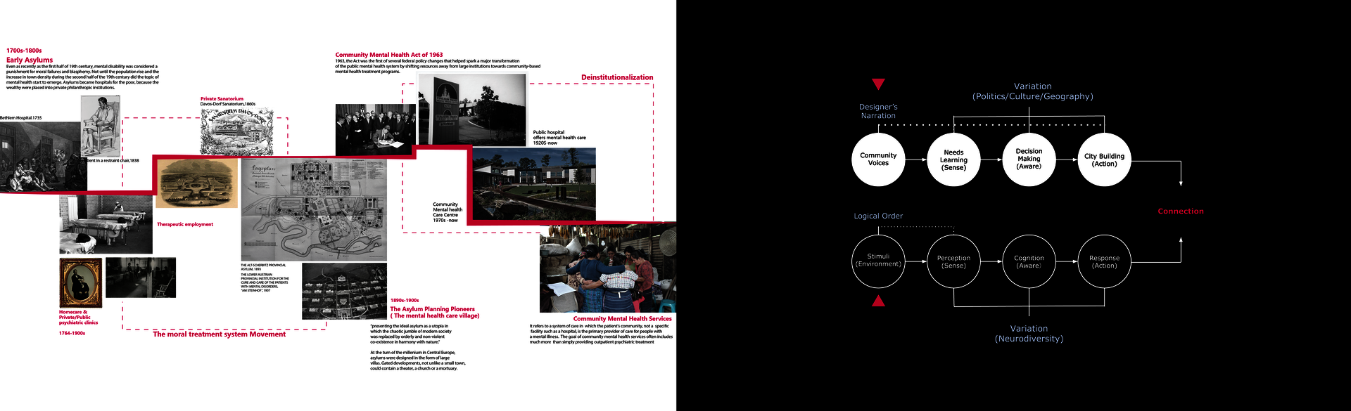
Judy Singer, a sociologist with autism, coined the term "neurodiversity" in the late 1990s. It refers to the concept that certain developmental disorders are normal variations in the brain.
Compared to the earlier perspective of ASD, ADHD, Dyslexia, and other neurological states as mental deficiencies, the concept of Neurodiversity emphasize that the way of thinking and behavior of the Neurodivergent population is a natural variation following the genetic diversity of human beings. The use of the terms Neurodivergent(ND) and Neurotypical (NT) indicates that variant neurological patterns and states are not necessarily patients who need to be treated and corrected by compelling. On the contrary, they represent the diversity of the human mental order as a different but equally valid perspective and identity. To some extent, this concept has helped society realize the stigmatization and criminalization that have been put on the ND population and helped more people with an objective, open attitude to understand and help the ND community. The concept has become more widely known and used in the autism human rights movement.
Though both are political words, the concept of neurominority has highlighted that neurodivergent people have been suppressed, abused, and unwelcome in public conditions since the first asylum was built. Neurominorities' deprived rights were not recognized until recent years. The community mental health act of 1963 and the deinstitutionalization movement is the start-up of recent recognition that neurodiverse people should get accessible and inclusive experiences in public spaces and local support. However, the struggles and frustrations neurodiverse people had felt in daily activities and the public realm are still mostly ignored by society and mainstream media nowadays.
Among all the urban context, urban public space system are the ones that are associated with local communication, social activities public voices most, and is where neurodivergent community tends to have the most sensory-related issues: urban environments(especially suburb areas)with homogenous sensory profiles offers limited experience led to under-stimulation
and dull living experience for residents; disconnected essential services scattered without organized structures and proper distribution; vehicle dominated public transportation circulation with the lack of navigation system and access for pedestrians, when many neurominorities do not have access to the car and driving abilities.
These existing conditions made neurominorities find it hard to attain an equivalent experience and access in urban lives. Being treated exclusively with living resources in both spatial and cultural public realms is one of the difficulties impeding them from becoming independent and enjoying equal rights.
Image
Historic context for neurodiversity and neurominorities
NARRATION: Explore through Neurodiverse lenses
Among all the public spaces, public street and streetside space systems are the ones that play the most critical role in modern daily lives. While it serves as the vital transportation circulation for commuting, it also connects functions and has the most prosperous and dynamic sensory environments. It is the most visited, most connected, and dynamic public space system in the modern city. It is the one that depends on personal movement and cognition perspective most, which is most impactful to neurominorities, especially the ones who take pedestrian roles.
In this thesis project, the focus lands on Urban walkingscape, which is the spatial environments and sensory profiles pedestrians perceive in walking through an urban public system. The following research aims to explore the potential re-interpretation of the existing urban walkingscape conditions, analyze its structure and patterns, and re-frame the potential structure of a more neurominorities-inclusive urban walkingscape system that offers proper sensory profiles, coherent navigation system, and pedestrian accessibility.
The uniformity of public space sensory profiles and the lack of transition zones between them make the urban public system a fragmented, unorganized, and irritating sensory chaos. The first step for a more neurominority-inclusive city vision is to respect the human population's varied sensory needs and accommodate more options of sensory experience for people's choice at will. Then establish a set of pedestrian-based circulation systems that serve as transitional zones between various sensory experiences, creating a smoother, more legible transitioning experience.
Urban public walkingscape is like the fingerprint of each modern city—it's uniquely based on local typography, political environments, and constantly shifting urban fabric. To better understand how sensory experiences shape urban walkingscape and create various layers of sensory profiles, a personal exploration journey in downtown Providence, RI was made and translated into a sensory mapping.
The mapping was built upon an annotation system that translates each distinguishable sensory source to signs that can be interpreted individually and as a whole. Lumped stimuli, scattered stimuli, linear stimuli, explosive stimuli, physical barriers, and closed space…The system consists of a series of annotations that reveals patterns and hidden topography of the urban public, bringing out the connection between urban walkingscape and existing spatial orders.
Progressive efforts were made to develop an annotation system that has the ability to describe more subtle and time-based sensory stimulation. The three-axis parameters: intensity, persistence, and predictability, are able to analyze sensory stimulation on three scales, how intense it is for human perception, how long it stays and is influential in the urban public context, and how advanced it can be perceived before actual happening so preceptors could have mental space and time to prepare for it. While some sensory stimulation has fatherly high predictability, the long consistency can be frustrating for acoustic sensory sensitive users, like construction site noise. On the other hand, a vehicle honk is sharp and unpredictable, with high intensity and low predictability, which can irritate many neurodiverse people with sensory processing issues.
Based on this new parameter annotation system, a research method of "lenses" was developed to analyze the existing urban walkingscape in downtown providence and sensory profiles in the public context. Instead of relying on a 2-dimensional master plan of the site, the method makes several cutting sections on the urban walkingscape, then applies lenses using the annotation systems to demonstrate the sensory stimulation occurring in each specific sensory scenario. Each segment's base and layers were printed on acetate and installed on a physical model of downtown providence, which highlighted several urban activator spaces that encourage pedestrian interactions and have distinguishable sensory profiles. By observing through these lenses and urban segments, the readers could navigate through the urban walkingscape in downtown providence from the perspective of sensory experience and spotting patterns and relationships of existing urban sensory environments.
Upon these sensory observation lenses, observers could see how urban public spaces were perceived in potential neurominority perspectives and how different visions could bring out different experiences in the urban public realm. This research method is an experiential tool to help designers understand the sensory environments in the urban public system and allow designers to develop and test potential renovating strategies in a responding system with adjustable parameter settings.
Image
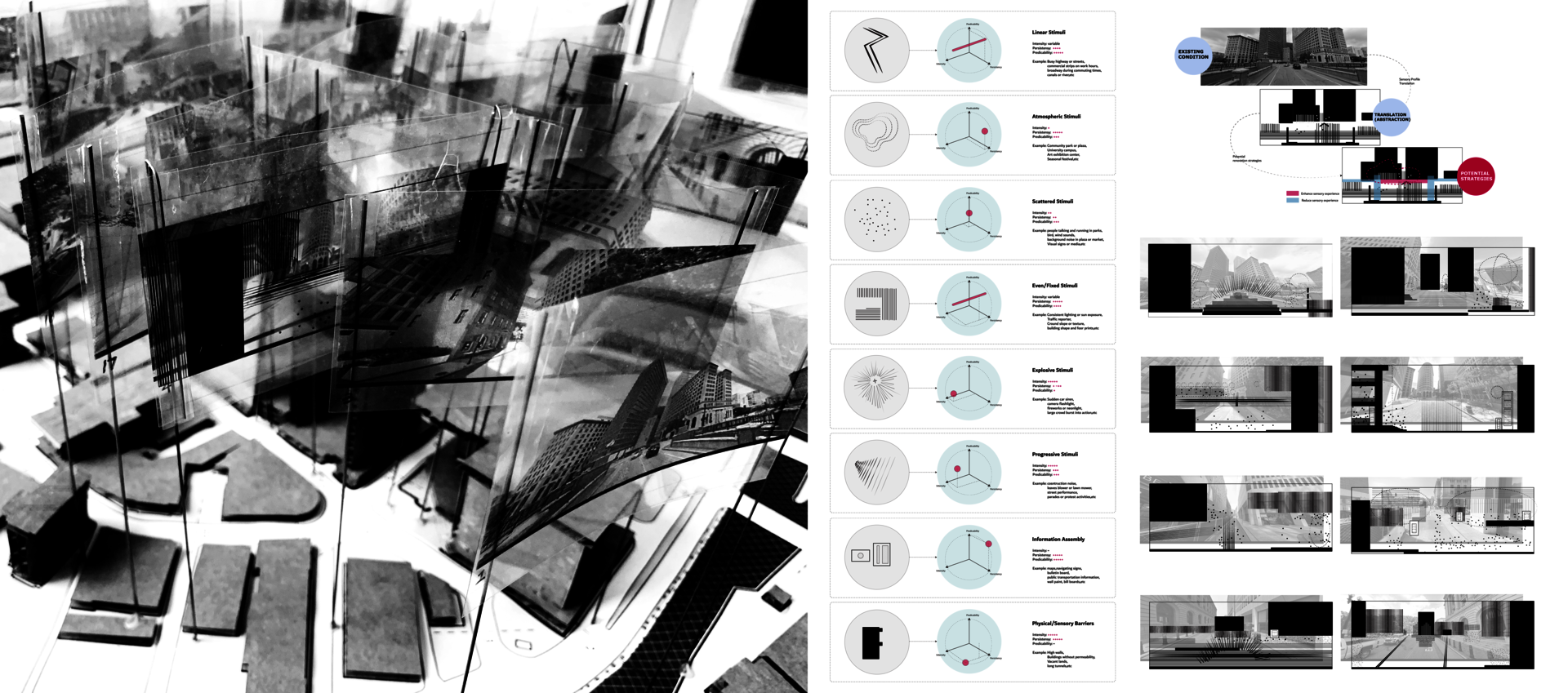
Parameter system for sensory stimulation, and developed lenses system
STRAREGIES: Spatial typologies and their sensory influences
While the first research method took the perspective of subjective experience in site, the second research method is established on objective studies of existing landscape design projects. Several most commonly used spatial typologies were summarized and categorized by studying existing projects and guidelines that focus on universal design and sensory experiences. Furthermore, by analyzing how designers use spatial orders to influence the site's sensory profiles, we could condense these strategies into six main types: Sensory buffer, Sensory Clarification, Sensory intermediation, Information clarification, Spatial clarification, and Spatial Integration.
Differences between these sensory intervention methods came from the subtle definition of layers of stimulation: Despite the layers of sensory stimulation, these methods can be summarized in 3 main categories: Buffer, Clarification, and integration.
By highlighting the frequency of each spatial typology used for each sensor intervention method, hidden relationships between spatial orders and sensory profiles can be revealed and become the guidance for potential renovating toolsets for a more sensory resilient walkingscape.
As the thesis selected Kennedy Plaza, a public transportation in downtown Providence, RI, as a further experimenting site, the main typology(design toolkits)that will be applied on-site as sensory resilience renovation experiments has to be versatile, can be widely used in busy areas, and offer high levels of accessibility for people with all levels of mobility. The overall cost is better to stay low, and the construction difficulties tend to be easier so the construction phases will not affect the local community's uses for too long. Among the most commonly applied spatial typologies, pavement is the one that fits best into the busy public transportation center role as the high level of accessibility, universality, and the spatial clarification functions it usually holds. The pedestrian typology's close relationship with pedestrian experience also helps build a pedestrian prioritized walkingscape system that focuses on straightforward navigation and legible information clarification.
Image
Common spatial typologies associated with sensorial functions in urban public environment
EXPERIMENT: Transportation Center as a Settleable Public Space
Image
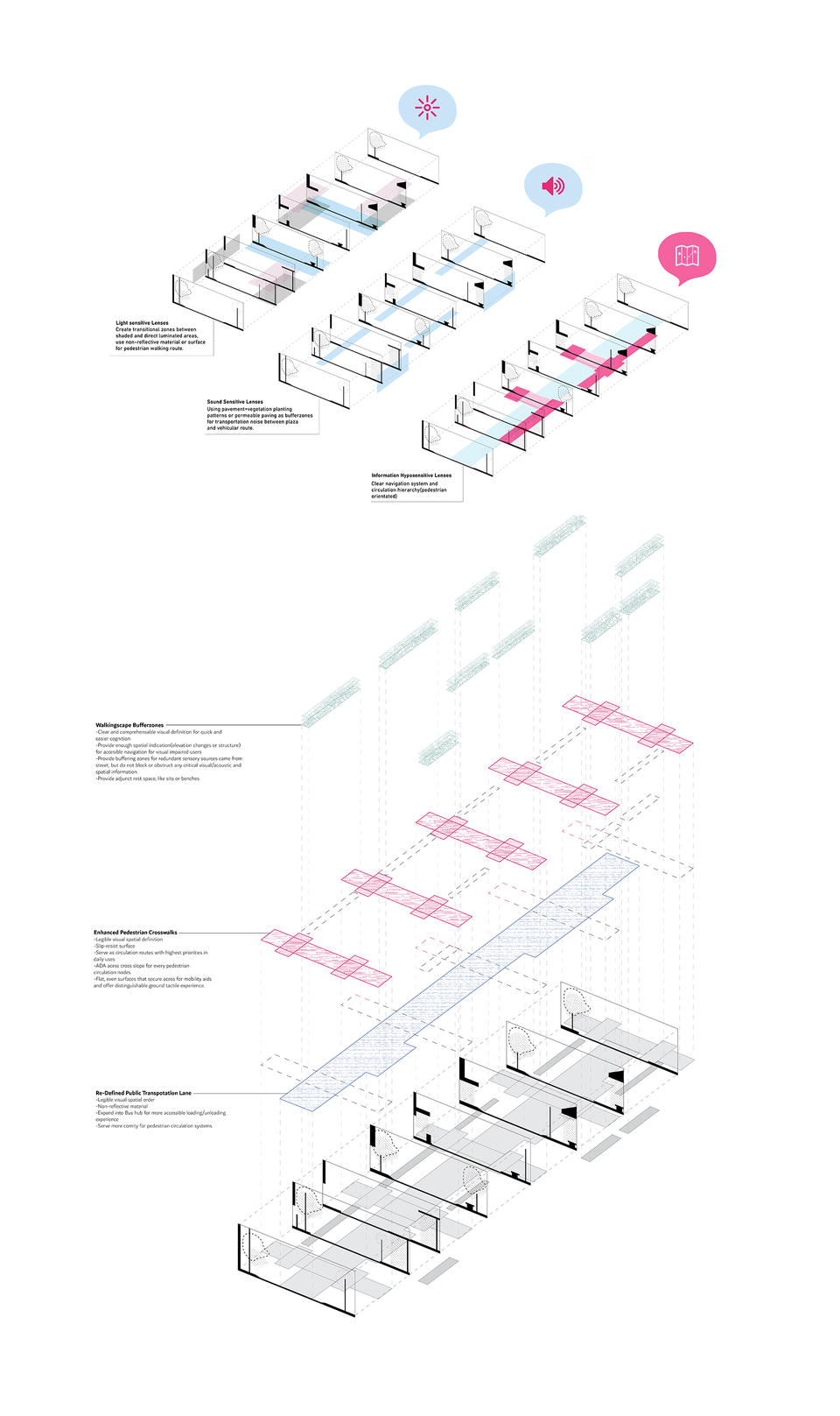
Fulton street through light,acoustic senstive and information hyposensitive lenses.Potential street renovation strategies for pedestrain prioritized walkingscape.
Image
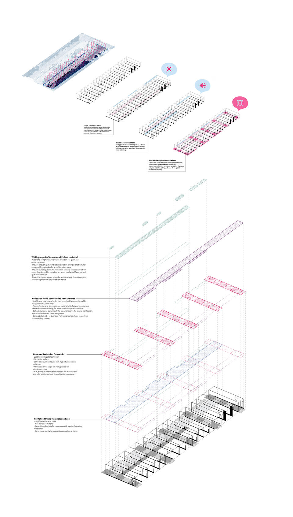
Washington street through light,acoustic senstive and information hyposensitive lenses.Potential street renovation strategies for pedestrain prioritized walkingscape.
Image
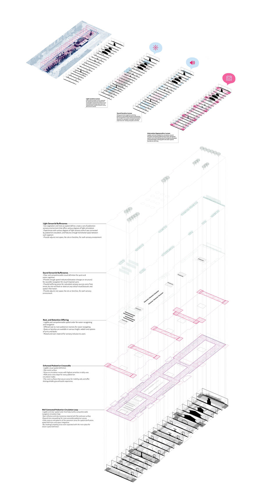
Kennedy Plaza through light, acoustic senstive and information hyposensitive lenses. Potential space renovation strategies for sensory resilient public plaza with coherent pedestrian circulation.
Image
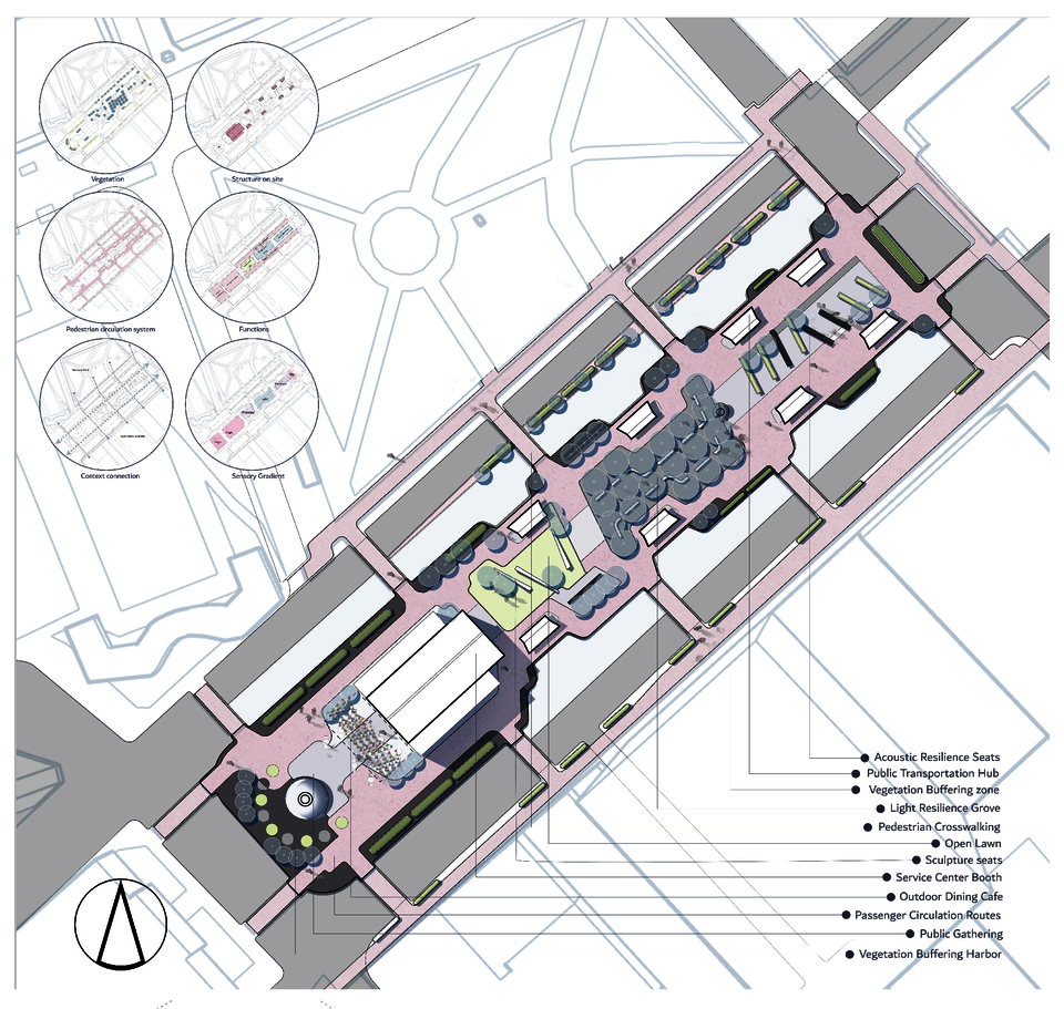
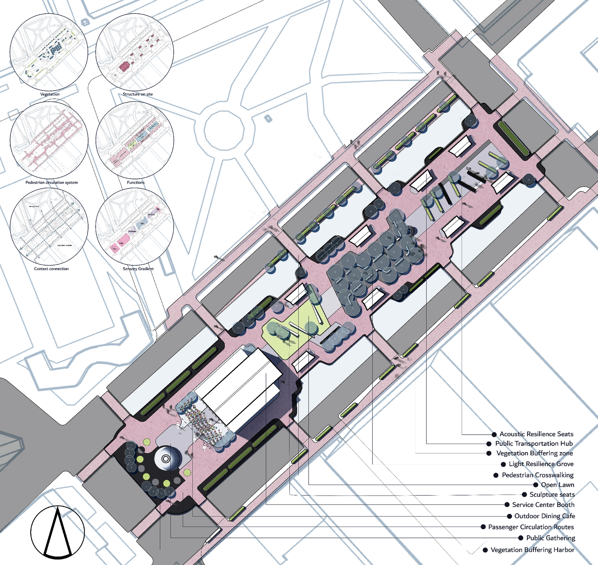
Master plan of Kennedy Plaza's neuro-inclusive Vision
Image
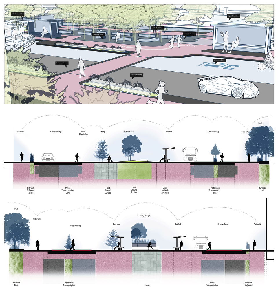
Space making elements in site, cutting sections of paving design based walkingscape renovation.
- Architecture
- Ceramics
- Design Engineering
- Digital + Media
- Furniture Design
- Global Arts and Cultures
- Glass
- Graphic Design
- Industrial Design
- Interior Architecture
- Jewelry + Metalsmithing
- Landscape Architecture
- Nature-Culture-Sustainability Studies
- Painting
- Photography
- Printmaking
- Sculpture
- TLAD
- Textiles