Alexis Violet

Unearthing Complexity

Unearthing Complexity investigates the hidden stories of the water and earth to foster a deeper awareness of non-human time scales and a more tangible understanding of the embodied experience of matter in the universe. Working toward a literacy of the water and earth in which they are recognized as living, changing bodies, the site of this multiscalar inquiry occurs in the coastal zones of the Narragansett Bay. Mapping studies at the scale of the bay relate visual representation to human perspectives on landscapes, while surface explorations at the scale of the body highlight the importance of sensory perception in contributing to our physical connection to the world. Multimedia representational experiments function as metrics of time telling to highlight cycles of constant change. Uncovering the hidden stories of our land and water tests the capacity for design processes to reorient us toward new modes of understanding and caring for our land.

PREFACE

For as long as I can remember, the water has been part of my daily existence. Though the ocean is often seen as a vast natural border between faraway lands, I view it as a great connector. No one owns the ocean, at least not in the same way people think they can own land. The water is always moving, always changing, constantly shaping the land and collecting stories over time.


I would like to acknowledge the water as a way of life in Narragansett Bay and elsewhere. It facilitates rituals, interactions, and connections between people and other life forms. Each wave crashing on the shore changes the land beneath it, even if it is at a scale we cannot see. At a geological level, the water shapes the land, carving different paths through the stratigraphy to create the landforms we know today. As glaciers melt and our waterscapes shift, so does our land. At a smaller scale, a variety of shells, sea glass, seaweed, rocks, debris, and other objects wash up with each wave, rearranging a new layer in the sand. We do not know exactly where the objects came from, but can imagine a story for each one.


As I walk along the beach looking at the shells and sea glass on Conanicut Island’s shoreline, I appreciate the beauty of each shell and its ability to host sea life. I think about the Narragansett people finding Quahog shells on the shore and also admiring this beauty, finding hidden meaning in the deep purples and bright white colors, taking the care to slowly craft the shells into beads, and giving them to loved ones as thoughtful gifts.I imagine the time it takes for a skilled maker to sand and polish each shell and delicately drill a hole into it so it can be secured on a string and worn on the body. To gift someone something from the ocean shows appreciation for the ocean as a gift itself. To then physically wear the gift illustrates a deep connection to the water, a connection I would like to carry forward in my life.


When I look out across the bay and see the boats in the distance, I remember what I have learned from my family and their stories of the water, whether here in Narragansett Bay, or in the waters around the island of Skiathos, Greece, where my family is from. My father tells stories of his adventures with my grandfather on the lobster boat—waking up at 3:00 every morning, setting up the boat, picking up the pots, resetting them, cleaning the boat, and selling the catch to the local community. I am reminded of the importance of only taking the gifts you need, and then sharing these gifts with the community as a form of nourishment. I realize the dedication and preparation required to maintain this lifestyle, the skills needed to survive the ocean’s power. I think of my grandfather tying knot after knot to create a strong net, physically connecting the fibers of rope together to build his life and practices. I think of the knowledge held within each knot, and hope to continue building my own appreciation of the ocean through this ritual type of making.


Though the water can be overwhelmingly powerful and dangerous, seen as an obstacle to overcome, I believe it can also be a place of healing and deep connection. I recognize that the water can hold stories of trauma, but it can also be a place of hope, as it is always in flux, always changing; it is alive. In acknowledging the stories the ocean holds, I have learned to see the water as a place of wonder and beauty, not an opportunity for extraction or a method of transporting goods for transactions. The water is supportive, filling in the gaps between lands and providing us with gifts that cross time and place. The stories in the water have taught me to find the beauty in everyday practices and rituals, and inspires me to continue the process of living with and caring for its great gifts.


This project is my gift to the ocean. 

Image

Animation of texture rubbing fading into rock at Taylor Point on Conanicut Island, RI

Animation of texture rubbing fading into rock at Taylor Point on Conanicut Island, RI

EXPLORATIONS

Much of the modern human world appears rather disinterested in time scales other than their own--time scales forced upon them by societal myths of progress and profit. As someone who strives to be actively aware of the multiplicities of time scales and life scales that exist, I would like to prompt people to consider an alternative to this narrative by designing a practice that pushes people to look at time in a non-linear way, in favor of a wider view of time and matter--one that is cyclical, malleable, and prone to change. 


These views of deep time combined with material investigations of coastal zones and the body lead me to the question: How can artifacts of geological processes between the water and the earth shift our understanding of land to foster a greater connection between humans and the planet across time scales?


I believe the answers to some of our anthropocentric issues lie in the past, and on/in the ground. In order to bring this interest into the physical realm, I would like to examine our relationship to the ground through various scales of life, time, and stories. The site of my inquiry lies at the intersection of the body and the land- the physical experience of touch that connects us to the ground. 


Using my personal experience of coastal spaces as evidence of passing time, I hope to reframe ideas of permanence by bringing people toward a deeper awareness of the hidden stories where the land and water meet. This occurs through a series of time-telling explorations in the form of texture rubbings, digital modeling and animations, mapping, material studies, and underwater video footage obtained throughout Narragansett Bay. 


Unearthing Complexity investigates geological processes of the water and earth in Narragansett Bay to reframe ideas of permanence, site, and representation. Uncovering the stories beneath these surfaces reveals coastal areas as critical zones of temporal change and fosters reconnection and grounding between our bodies and our planet.

Image

Animation of texture rubbing fading into rock at Taylor Point on Conanicut Island, RI

Animation of texture rubbing fading into rock at Purgatory Chasm on Aquidneck Island, RI

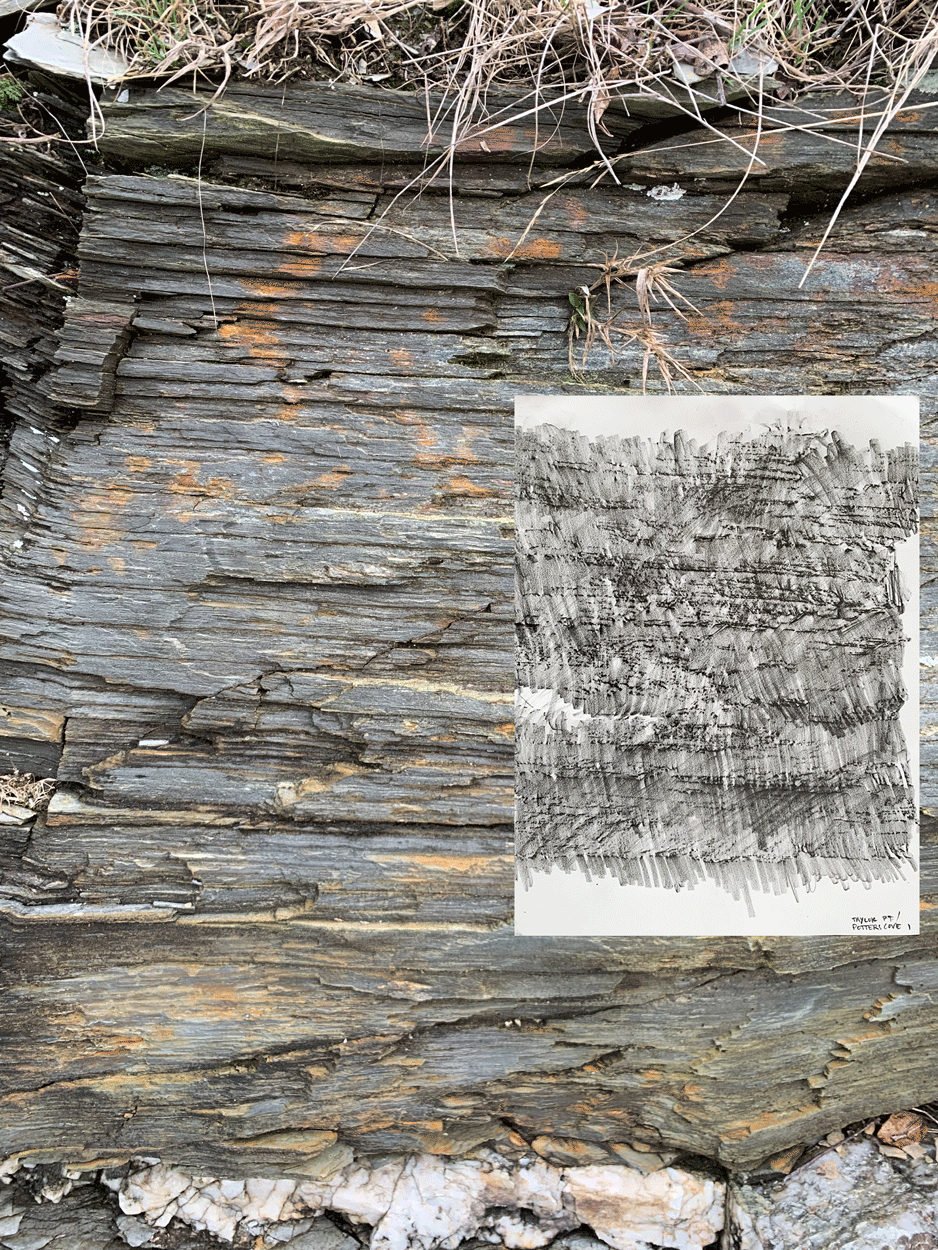
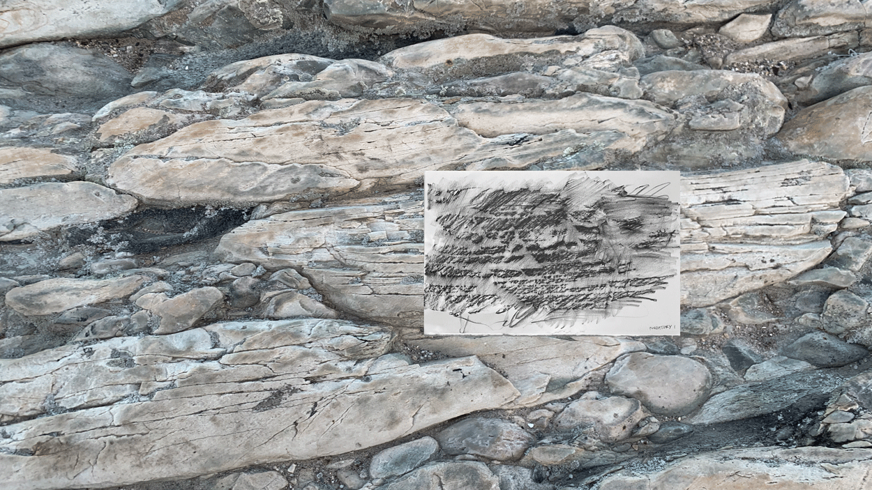
SITE: WATER MEETS EARTH

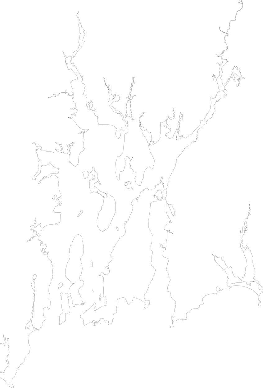
This multiscalar site of inquiry focuses on the evidence of geological processes present in the land with which I am most familiar, the land forming Narragansett Bay. As New England’s largest estuary, the land and water in this area feature many points of geological and hydrological significance. Each boulder, rock, and even grain of sand can be seen as a powerful artifact of earth’s history if one takes the time to look.

These flowing water bodies have taken many shapes over the years. Their stories began long before humans ever set foot on the land, long before the land was covered with water and could even be classified as a bay.

The Narragansett Bay of today first became somewhat recognizable only 18,000 years ago after the Last Glacial Maximum. The 3500 miles of streams and rivers that travel through the watershed and drain into today’s bay are remnants of the Laurentide ice sheet that flowed over the land 18,000 years ago. This massive ice sheet carved through the existing sedimentary basin as it melted, its pressure weighing down segments of earth beneath to drop crustal blocks and form a basin and range system. The moving and melting glaciers left behind waterways in the land that formed rivers and streams. They gouged out deeper channels in the bay, exposing the older bedrock layers and leaving behind the segments of land we now see as Conanicut and Aquidneck islands. The ice pushed the land beneath it into piles of sand and gravel, forming the coastal end moraines of southern Rhode Island [Save the Bay].

Eventually the ice retreated as the planet continued to warm, leaving behind a freshwater flood that formed what is known as Lake Narragansett. This proglacial lake only lasted for approximately 500 years before rising sea levels flooded the area and filled the valley, giving the bay the brackish water it contains today and earning it the classification of a ria, or a drowned river valley that is open to the ocean. The flooded glacial valleys beneath the surface of the bay continue to shift along the faults in its basin and range system [Save the Bay].

The production of sedimentary rock from primordial Earth-rock is the process by which the Earth has acquired a tangible history. More: this his- tory includes a detailed record of the evolution of life, and, ultimately, of intelligent beings, a story more intricate by far than the recording of physical and chemical phenomena. -Jan Zalasiewics, The Earth After Us

The prequel to what I will call this “geologically modern” story of the bay goes even further back in time, before the bay even remotely resembled its current form, before human life was even close to evolving. Geologists have discovered artifacts at Beavertail Point in Jamestown that provide evidence of a previous transcontinental link with Europe and Africa hundreds of millions of years ago in the form of trilobite fossils. These non-swimming ancient horseshoe crabs were not native to America, as their fossils matched those of trilobites found in the rocks of Spain, Portugal, and Morocco. During the Paleozoic Era 300 million years ago, North America, Europe, and Africa collided to form the supercontinent Pangaea, during which Rhode Island acted as a “bumper in the crash,” with its some of its bedrock sliding underneath and some sliding on top of an ancient African mountain range [Lewis].

In the pre-prequel of this dramatic tale of collision (525 million years ago), the land that is now Rhode Island was once part of a volcanic island chain in the Southern Hemisphere that gradually (over hundreds of millions of years) inched closer and closer north to join what is now Africa, and then shifted westward to join what is now North America [Lewis].


These coastal areas provide us with pieces of physical evidence, small scenes of the cataclysmic drama of which we are largely unaware that has unfolded over millions of years. The artifacts hint to us that the earth is not static, but is a living, breathing being whose elements are constantly shifting and rearranging. The in-between place where land meets water offers a wealth of geological information and artifacts that bring the faraway concept of time down to earth. I hope to uncover more of the earth’s hidden stories at this site of inquiry.

“The new universality consists in feeling that the ground is in the process of giving way.”

― Bruno Latour, Down to Earth: Politics in the New Climatic Regime

Image

animation of heightfield derived from texture rubbings and manipulated to look like water

Animation of heightfield derived from texture rubbings and manipulated to look like water.

TANGIBLE HISTORIES

"The surface of the Earth is no place to preserve deep history. This is in spite of—and in large part because of—the many events that have taken place on it. The surface of the future Earth, one hundred million years from now, will not have preserved evidence of contemporary human activity. One can be quite categorical about this. Whatever arrangement of oceans and continents, or whatever state of cool or warmth will exist then, the Earth's surface will have been wiped clean of human traces. For the Earth is active. It is not just an inert mass of rock, an enormous sphere of silicates and metals to be mined by its freight of organisms, much as caterpillars chew through leaves. Nor will it be inert, a hundred million years into the future. It is a dynamic system, powered from inside by the heat generated from the radioactivity within its interior." -Jan Zalasiewics, The Earth After Us

While I strive to uncover hidden stories beneath the surface, I must first engage with the surface itself. These rock texture rubbings present evidence of reciprocity and touch, of the communing of human activity with the environment. The act of tracing covers the surface and uses it as a mode of transferring information. Our representations do not capture every detail; we are limited to the high points transferred onto the sheet and must infer what is left between. But this method documents a tangible history of change. It captures fleeting moments in the earth’s life into artifacts

Retracing the same rocks six months after the first experiment provided me with tangible proof of geological change. Though six months is by no means a geologically significant time scale, the topography picked up by the paper highlighted small shifts in certain rocks that bring the geological time scale closer to the human time scale than expected. Not all of the rubbings noticeably changed over the six months, depending on the type, hardness, and location of the rocks. The most obvious changes occurred in the  already flaky mica sheets in the intertidal zone of Taylor Point, and the high foot-traffic areas of  metamorphic conglomerates at Purgatory Chasm.

Image

Animation of fading contour lines derived from texture heightfields.

Animation of fading contour lines derived from texture heightfields.

ERODING TOPOGRAPHIES

"There is no such thing as dry land. Wetness is everywhere to some degree. It is in the seas, clouds, rains, dew, air, soils, minerals, plants, animals. The sea is very wet; the desert less so. So, when we experience ‘water’ on the other side of a line that allegedly separates it from ‘land’, we know it to be by design, design that articulates a surface for habitation. This surface has served as a ground for experience, understanding and knowledge. Today, however, with rising seas, warming temperatures, and the increasing frequency of floods, this surface along with the edifice of civilization and certainty built upon it is threatened, calling into question the act of separation that brought it into being...Yet, this is a surface that exists under perpetual threat of erasure by a wetness that defies separation and a water that refuses its place, a threat that is at new levels with rising seas, intensifying storms, and increasing flood events from global warming. These problems raise questions about how the surface is articulated and where the line is drawn; but they also raise questions about the necessity of the surface itself. Is it found in nature, or has nature followed from its assertion? Are there alternatives to an earth surface and to the act of separation that brings it into being?” -Anuradhapura Mather and Dilip da Cunha, Wetness Is Everywhere; Why Do We See Water Somewhere?

In manipulating my coastline encounters in the digital realm, I am presented with more watery bodies. As these rocky surfaces are digitally stretched and altered, they gradually shift toward wavy and watery forms.

This recursivity in form from earth to water calls back to the impacts of celestial bodies on the rhythms of earthly bodies and highlights the value in viewing the world in terms of degrees of wetness and bodies of water. These digital representations speak to processes of weathering and erosion to reframe conceptions of static permanence. 

Image

Animation of shifting water levels in Narragansett Bay based on digital topobathymetric model,

Animation of shifting water levels in Narragansett Bay based on digital topobathymetric model,

MAPS IN MOTION

"But there are still plenty of shifting and potentially doubtful phenomena out there, including cartographic ‘facts’ like the shapes of nations, borders, mountains, and rivers, that will continue to disturb our geographical certainties. The truth is, we want to have a world that is not totally known and that has the capacity to surprise us. As our information sources improve and become ever more complete, the need to create and conjure new places that are defiantly off the map also grows.” -Alastair Bonnett, Unruly Places [Sandy Island]

The way we currently draw maps is unsurprisingly based on our human perceptions of the land. When the land meets the water on a map, we see a line of demarcation. The contour lines of the topography, the labels, the vegetation, the colors, the data, and other elements abruptly stop in the face of an opaque blue shroud. This representational decision highlights how little we know about the ocean and how little we care about the surfaces we cannot easily traverse. By mapping in this way, we ignore the unknown. We forget that what is beneath the opaque blue of the water is in fact more land, more solid yet ever changing ground, more topography lines, more vegetation, and more life. I prefer to view the coast not as a line, but as an ever-changing zone, one that should have its own methods of documentation. 

If everything is in constant flux, maps can only accurately represent the surfaces of the earth for a sliver of time. To draw our world in a way that respects its rhythms, tides, and vast histories, we must make maps that move. 

Image

Animation of topographic and topobathymetric mapping techniques.

Animation of topographic and topobathymetric mapping techniques.

video composition of underwater footage in Narragansett Bay


RISD Grad ShowRISD Grad Show

Attach a Drupal Library