Image
Aleece Mount
The Root of Culture: Human Ritual and the Soils of West Virginia
The Cumberland Mountains of Southern West Virginia are home to mountaintop removal. The strip-mining practices have removed fertile soil, altered water courses, deeply polluted the land, and stripped people of their wealth, resulting in some of the nation's worst health, education, and economic conditions. The communities of this watershed live at the heart of the economic and political forces that undermine community and ecological well-being.
Southern West Virginia has a deep and continued history of living off the land. This culture, however, has declined as mining and soil degradation have increased. To restore the health and vitality of the people and ecosystem, the people of these communities need to transform how they interface with their land. The foundation of sustained cultural and economic expression is healthy soil and the human activities that support them. Regenerating soil health by revivifying agrarian culture develops a resilient economy built from the bottom up. This thesis subverts the exploitative forces that eroded the Guyandotte communities through the revivification of a local agrarian economy.
Image
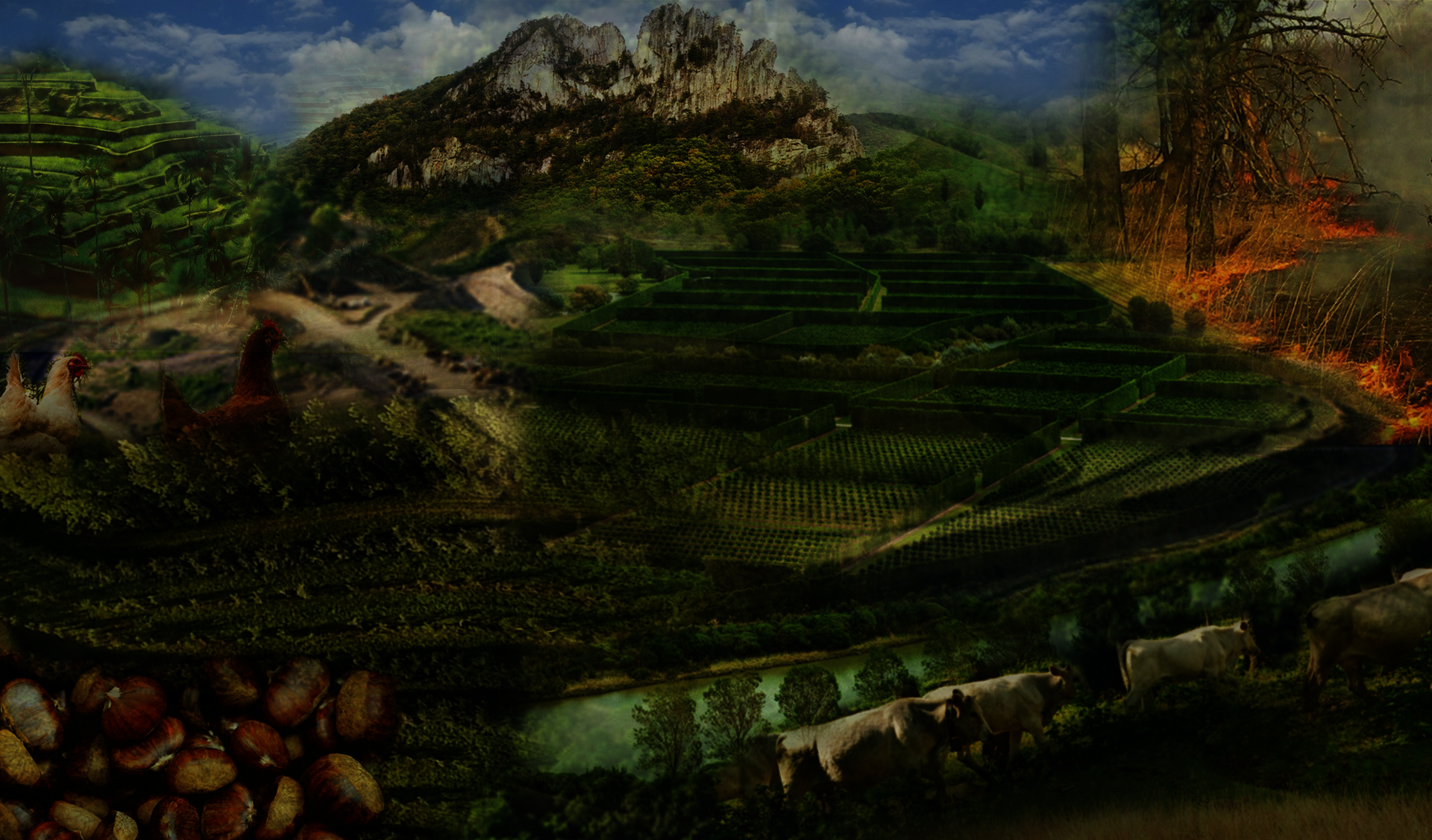
Design Collage
Photoshop
30 in x 17 in
2023
A collage of different case studies and materials that have been a source of inspiration for the design process. These images are layered together over a mountainous landscape that has been strip-mined for coal. Plants, animals, fire, water, and earthworks are used to regenerate the soil lost in the mining process.
Image
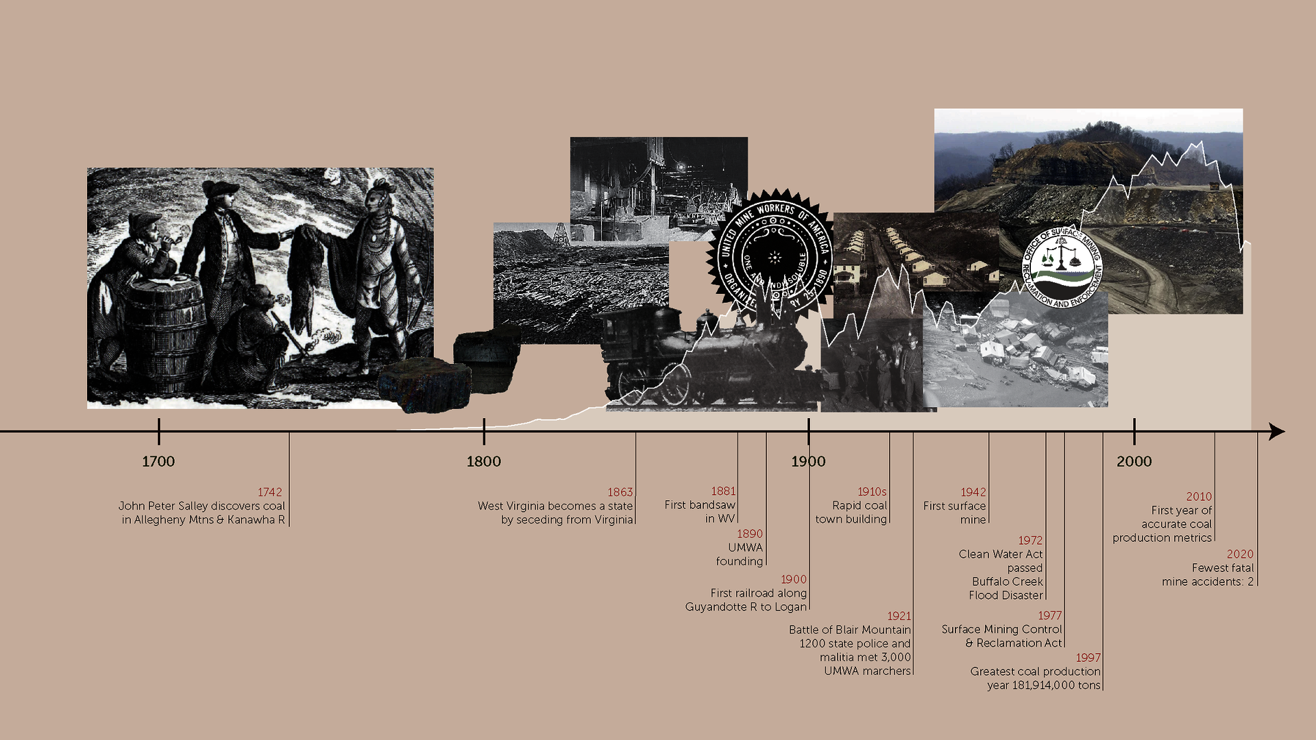
Historical Overview of the Southern Coal Fields of West Virginia
Illustrator
16 in x 9 in
2023
The Cumberland Mountains of West Virginia have been on the front lines of exploitation for the last few centuries.
From the fur trade to lumber to coal, the region has been a major economic generator. However, this wealth was hardly seen by the people who lived there. Highly exploitative labor practices and price fixing by the coal companies kept the people poor and dependent on the mines. The Battle of Blair Mountain, little known by people outside the region, was the largest labor uprising in US History. Hundreds of workers died, and thousands of police and national guard troops were used to silence the movement.
Labor and land rights are still unsolved issues as the coal industry becomes more exploitative and destructive with mountaintop removal mining.
Image
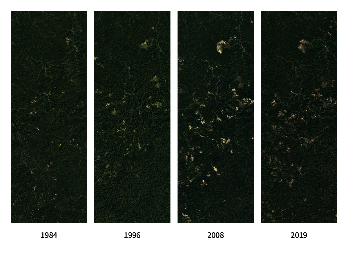
Progression of Mountain Top Removal
Google Earth Aerial Sequence
8 in x 6 in
2023
After the 1977 Surface Mine Control and Reclamation Act, mountaintop removal coal mining became the method of choice to bypass the prohibition of strip mining. By the 1990s, tens of thousands of acres of mountains were being leveled each year. Today, nearly 1.5 million acres of the Cumberland Mountains have been leveled, and thousands of headwater streams have been buried by the “overburden” pushed off the coal seams.
Image
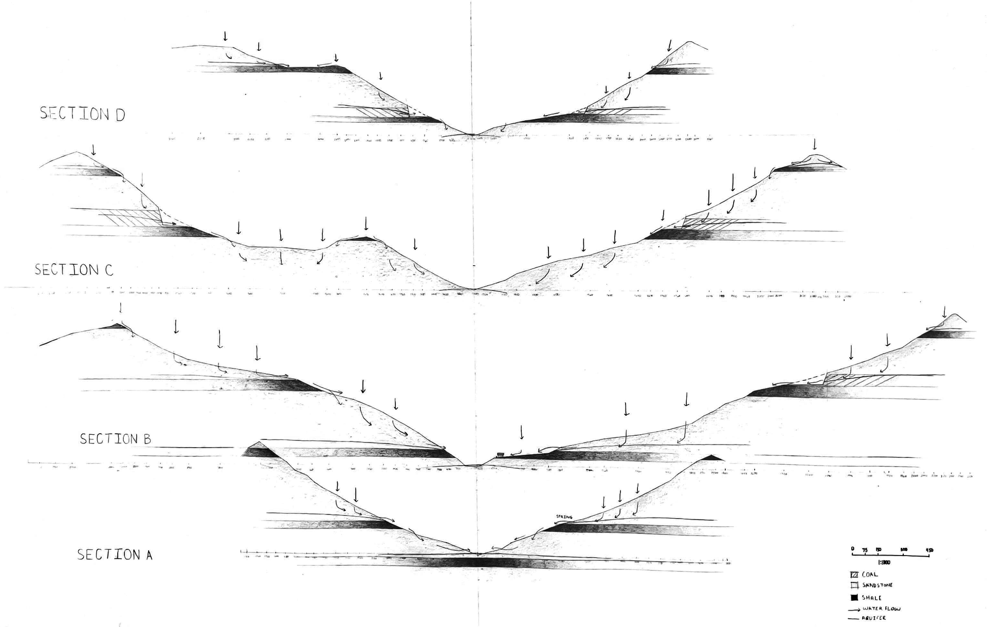
The Relationship of Geology & Hydrology
Graphite on Vellum
24 in x 46 in
2023
The geology of the region is unique in that it is a layer cake of sandstone, shale, and coal. The coal layer, actually the aquifer, sits on a layer of impervious shale (dark band). Rainwater percolates through the sandstone and collects in the coal layers perched on top of the shale. Springs and streams emerge at the elevation of the shale layers. This path is also the path that acid mine drainage pollution emerges from underground coal mines. Given the nearly level nature of the layers, strip mines create shelves or terraces at nearly the same contour around an entire mountain.
Image

Scars in the Land
GIS Contour Mapping
48 in x 36 in
2023
A highly detailed contour plan of a mountaintop removal site and contour strip mining. Because of the dense tree cover, it is difficult to grasp the level of disturbance these mines cause. The changes in contour density also hint at the sandstone and shale layers of the bedrock.
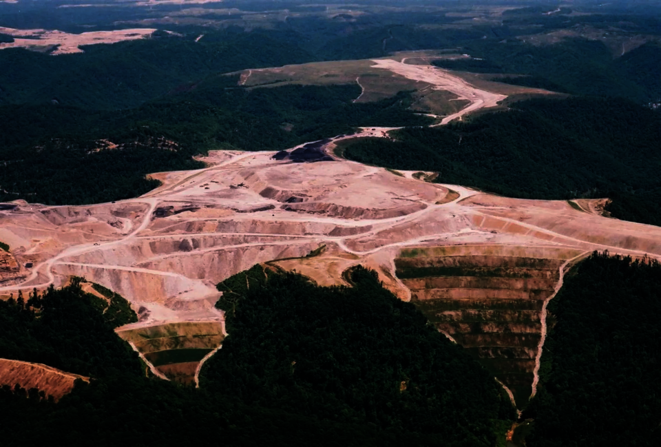
Mountain Top Removal
Digital Photograph
12 in x 8 in
WKU Public Radio, 2022
An aerial view of a mountaintop removal site and the terraced “overburden” covering headwater streams in the foreground. The orange water seen below is a sign of heavy metal pollution called acid mine drainage. The area in the background is a “reclaimed” mine where the mine operator is supposed to revegetate the mine surface and stabilize the slopes to prevent pollution and landslides.
Current reclamation methods are inadequate to address the deep disturbance the mining methods created. Often the end use of these mines is a grass field that might support some deer, a golf course, or a small air field.
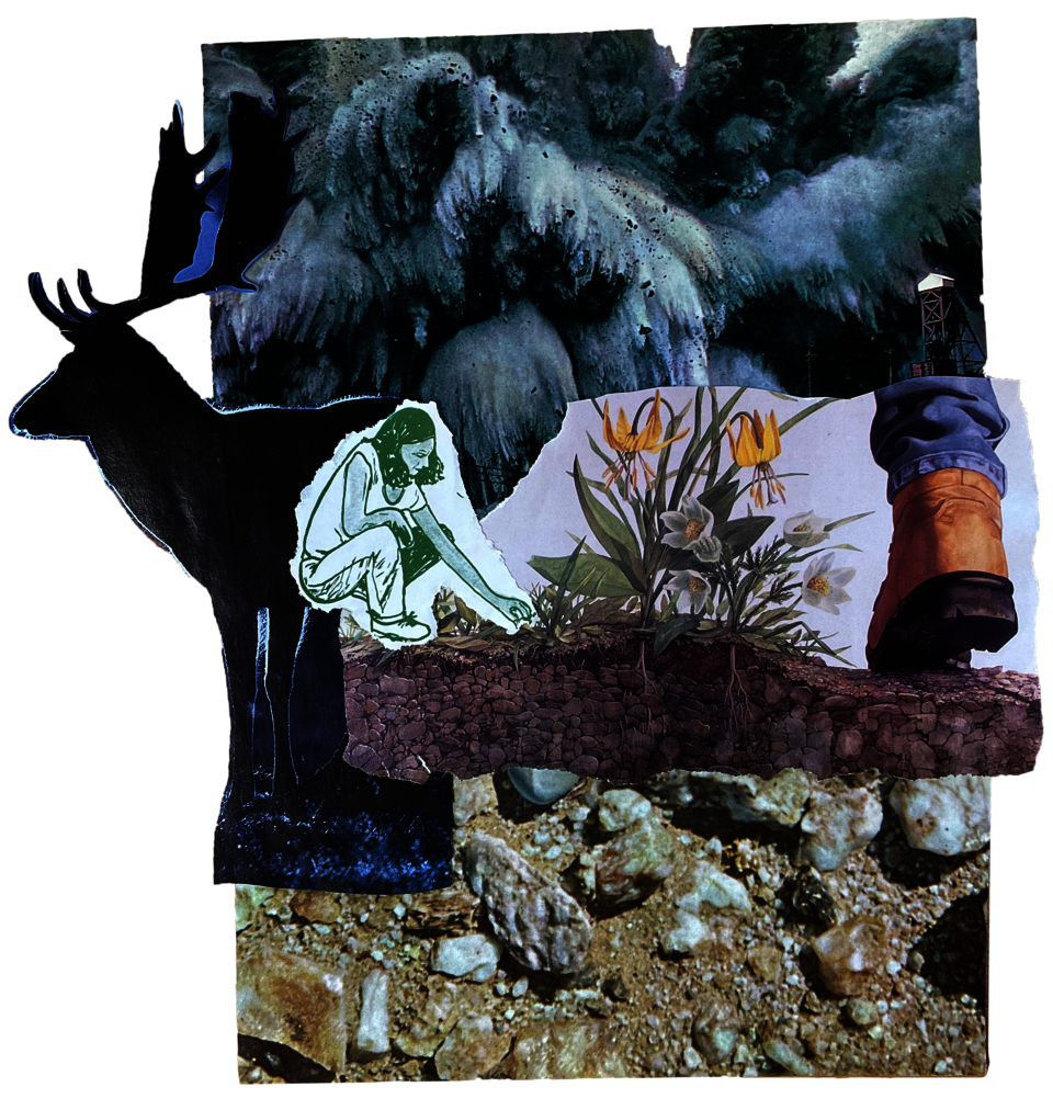
Positive and Negative Forces
Magazine Collage
12 in x 8 in
2023
An aerial view of a mountaintop removal site and the terraced “overburden” covering headwater streams in the foreground. The orange water seen below is a sign of heavy metal pollution called acid mine drainage. The area in the background is a “reclaimed” mine where the mine operator is supposed to revegetate the mine surface and stabilize the slopes to prevent pollution and landslides.
Current reclamation methods are inadequate to address the deep disturbance the mining methods created. Often the end use of these mines is a grass field that might support some deer, a golf course, or a small air field.
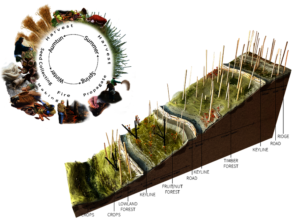
Cycle of Activity & Zoning Uses
Illustrator collage; Cardboard & Clay Model
18 in x 10 in
2023
emoval site and the terraced “overburden” covering headwater streams in the foreground. The orange water seen below is a sign of heavy metal pollution called acid mine drainage. The area in the background is a “reclaimed” mine where the mine operator is supposed to revegetate the mine surface and stabilize the slopes to prevent pollution and landslides.
Current reclamation methods are inadequate to address the deep disturbance the mining methods created. Often the end use of these mines is a grass field that might support some deer, a golf course, or a small air field.
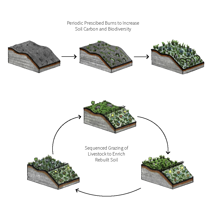
Management Methods
Pen and Marker on Trace
8 in x 8 in
2023
An aerial view of a mountaintop removal site and the terraced “overburden” covering headwater streams in the foreground. The orange water seen below is a sign of heavy metal pollution called acid mine drainage. The area in the background is a “reclaimed” mine where the mine operator is supposed to revegetate the mine surface and stabilize the slopes to prevent pollution and landslides.
Current reclamation methods are inadequate to address the deep disturbance the mining methods created. Often the end use of these mines is a grass field that might support some deer, a golf course, or a small air field.
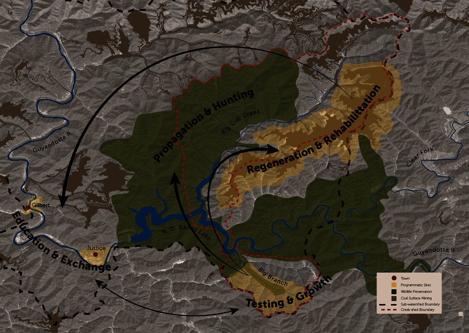
Programmatic Plan
Illustrator
13 in x 9.5 in
2023
An aerial view of a mountaintop removal site and the terraced “overburden” covering headwater streams in the foreground. The orange water seen below is a sign of heavy metal pollution called acid mine drainage. The area in the background is a “reclaimed” mine where the mine operator is supposed to revegetate the mine surface and stabilize the slopes to prevent pollution and landslides.
Current reclamation methods are inadequate to address the deep disturbance the mining methods created. Often the end use of these mines is a grass field that might support some deer, a golf course, or a small air field.